
If rapidly intensifying Hurricane Milton’s devolving core tracks northeastward from Orlando after landfall as projected, Brevard County would get socked by hurricane-force gusts and tropical-storm-force sustained winds — with fiercer weather striking Titusville than Melbourne, said Bryan Norcross, a Fox Weather hurricane specialist.

“The corridor of heaviest rain and gustiest wind will be on the left side of the track with this storm. And that corridor is going to go, best we know, right through the Orlando area. North of there, up all the way to Jacksonville, is a corridor of what we think will be pretty extreme inland weather,” Norcross said.
“South of that line, which is more or less the track of the storm, there’s still going to be hurricane-force gusts and so forth. And, some water rise above normal high tide — but not extreme, because the winds will be coming off the land for the most part,” he said.
Sustained storm winds are calculated by recording an average speed during a 1-minute period, per the National Weather Service. Tropical storm winds range from 39 to 73 mph. Hurricane winds clock in at 74 mph and greater.

For the sake of context, the Melbourne EF0 tornado that ripped off roofing, toppled trees and scattered debris in June in the Bowe Gardens subdivision near Sarno Road only packed peak wind speeds of 75 mph. So that twister represented the very bottom of the Category 1 hurricane wind scale — which ranges up to 95 mph.
Commercial Water Damage Cleanup Tips – PuroClean of Melbourne
Monday afternoon, Brevard officials declared a state of emergency and warned Milton was forecast to impact the Space Coast as a Category 1 hurricane, starting Wednesday afternoon through late Thursday.
“The latest forecast from the National Hurricane Center projects Brevard County could see 6-8 inches of cumulative rain (this past Sunday through late Thursday; 10-plus inches in isolated areas) and sustained winds of 70-80 mph, with higher wind gusts,” a press release said.
Norcross rose to fame as chief meteorologist for WTVJ-TV in Miami when he spearheaded a 23-hour marathon live broadcast while Hurricane Andrew decimated much of South Florida in August 1992. He spoke with FLORIDA TODAY about Milton’s looming path during a Sunday afternoon phone interview, shortly before flying from his Miami home to Fox Weather headquarters in New York City.
“My biggest advice is, be ready for the power to be out — perhaps for an extended period of time,” Norcross said.
“Because we’re talking about potential for massive power outages involving millions of people. And there are only so many power crews — not to mention everything going on with Helene. I’m not a power expert, but common sense says that if we have large areas without power, it’s just going to take longer than normal to get the power back on,” he said.
Hurricane David struck Space Coast in 1979
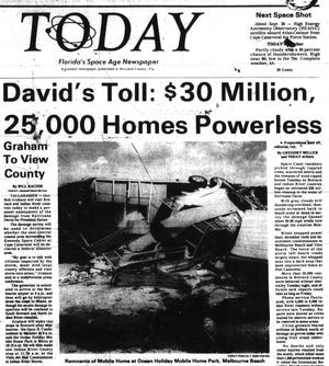
For years, Brevard emergency officials have reminded Space Coast residents that their neighborhoods have only seen tropical storm-force sustained winds — not hurricane-force sustained winds — since Hurricane David struck during President Jimmy Carter’s administration.
On Sept. 3, 1979, David slid northward along the Florida coastline before making a landfall packing 90 mph winds on Brevard’s barrier island about 20 miles south of Melbourne, according to a National Weather Service historical narrative.
“Nine tornados were reported along the coast doing mostly minor damage and causing no serious injuries.The strongest of David’s tornadoes destroyed or damaged about 50 trailers in Melbourne Beach, severelydamaged a condominium, and did $1,500,000 damage to a shopping center,” the narrative said, referring to Port Malabar Shopping Plaza in Palm Bay.
David’s winds had previously screamed up to Category 5 territory and killed about 2,000 people in the Dominican Republic. But the hurricane weakened drastically before reaching Florida.
“It was the first hurricane to strike the Cape Canaveral area since the hurricane of 1926, but there was debate among longtime residents whether David was really at hurricane strength in Brevard Co.,” the NWS historical narrative said.
“Residents had braced for a major hurricane, but David was officially only a minimal hurricane at landfall with the strongest winds remaining offshore. Tides were three to 5 feet above normal near the eye track and 1 to 2 feet above normal elsewhere on the Florida east coast,” the narrative said.
In October 2016, Hurricane Matthew generated hurricane-force sustained winds of 78 mph — with a gust of 107 mph — as measured by anemometers mounted to towers a full 54 feet above ground level across then-Cape Canaveral Air Force Station, according to a NWS storm summary.
By comparison, Matthew’s top sustained winds at the Cocoa Beach Pier clocked in at 60 mph, where a peak gust hit 67 mph, NWS records show. An anemometer at Trident Pier at Port Canaveral recorded top sustained winds of 52 mph with a gust reaching 72.
Rick Neale is a Space Reporter at FLORIDA TODAY. Contact Neale at[email protected]. Twitter/X: @RickNeale1
Call PuroClean Today for Your Water Damage Restoration Needs
PuroClean’s property restoration experts are available 24/7 to help with fire damage, water damage restoration, mold remediation, biohazard cleanups, and more. As the “Paramedics of Property Damage®,” we are the first responders of property restoration, providing emergency service when you truly need it. We assist both residential and commercial clients. To schedule an appointment with the PuroClean of Melbourne office, please visit our website or call us at (321) 378-2400.